Optical sensors allow you to have a realistic image (visible domain) or almost (near infrared), but they are blind at night and under cloudy cover. To characterize an agricultural landscape, optical images will be adapted.
| Pleiades 1 (1A, 1B) | Order Pleiades 1 (1A, 1B) |

Fully funded, manufactured, owned and operated by Airbus, the Pleiades satellite constellation provides very high resolution optical imaging that offers an extremely high level of detail. With four satellites of the same resolution of 50 cm and ultimate reactivity. The system provides both panchromatic and multispectral products with one of the largest footprints. The agility of the Pleiades allows them to be very responsive to end-user requests and to obtain and provide data in record time. Designed for civilian and military users, the system is particularly suited for emergency response and change detection
| Description du satellite | |
| Main Mission | |
| Instrument Type | |
| Revisit time | |
| Resolution class | |
| Swath width | |
| Data collection capacity | |
| Cycle coverage | |
| Launch date | |
| Orbit | |
| Altitude | |
| Sensor Specifications |
|

| SPOT 6,7 | Order SPOT 6,7 |
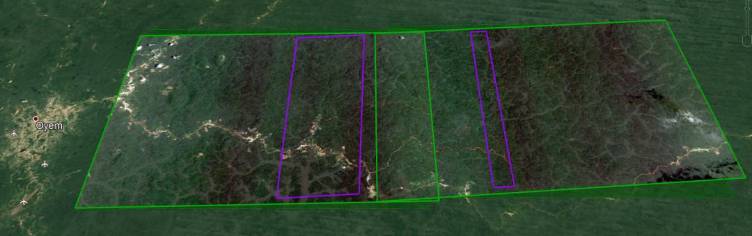
Ville d'Oyem, Gabon
SPOT-6 and SPOT-7, two optical Earth observation satellites with a resolution of 1.5 m / pxl, were designed to continue the SPOT-5 mission to obtain high-resolution broadband images and provide satellite data until 2023. The construction was initiated by Spot Image of Toulouse (France) and EADS Astrium in 2008, and officially announced in mid-2009 by Eric Beranger, CEO of Astrium Services. SPOT 6 was successfully launched on 9 September 2012 by the Indian polar satellite launcher and was followed by SPOT 7 on 30 June 2014. The technology allows users to obtain high-quality ortho-images as well as broadband satellite images that complement the very high-resolution Pleiades data.
| Optical system | |
| Detectors |
|
| Spectral bands |
|
| Fauchée | |
| Dynamic range on acquisition | |
| Localization Precision Specification |
|
| WordView | Order WordView |

The DigitalGlobe constellation remains the center of our innovation. DigitalGlobe's WorldView is able to discern objects at the Earth's surface as small as 31 cm in the panchromatic and will collect the 4-band multispectral at a resolution of 1.24 meters. This advanced resolution will provide customers with accurate and unprecedented views for 2D or 3D mapping, change detection, and image analysis.
| Sensor resolution (or GSD), distance from the ground sample; off-nadir is geometric mean) |
|
| Revisit time | |
| Resolution class | |
| Tape Width | |
| Data collection capacity | |
| Cycle Coverage |
|
| Launch Date | |
| Orbit | |
| Altitude | |
| Sensor Specifications |
Panchromatic: 450-800
|
| SUPERVIEW-1 | Order SUPERVIEW-1 |
SuperView satellites will offer satellite imagery with a 0.5 meter panchromatic resolution and a 2 meter multispectral resolution over a 12-kilometer band. The spacecraft is very agile providing several modes of collection, including long band, multiple collection bands, multiple point targets collect and stereo imaging. SuperView-1 satellite sensor (0.5 m) is a Chinese remote sensing satellite operated by Beijing Space View Technology Co. Ltd., China. The constellation is very agile and works in four acquisition modes:
| Altitude |
|
| Sensor strips |
|
| Spatial resolution |
|
| Bandwidth | |
| On-board storage | |
| Review Time | |
| Daily Capacity |
| GeoEyes | Order GeoEyes |
The GeoEye-1 satellite sensor was successfully launched on September 6, 2008. The satellite, which was launched at Vanderberg Air Force Base, California, provides a resolution of 0.46 meters. The GeoEye-1 satellite sensor is equipped with the most sophisticated technology ever used in a commercial remote sensing system. This sensor is optimized for large projects, as it can produce more than 350,000 square kilometers of multi-spectral, pan-sharpened satellite imagery every day.
| Release date | |
| Camera Modes |
|
| Resolution |
|
| Spectral Band |
|
| Metric/geolocation accuracy | |
| Orbital Altitude | |
| Orbit Type/Period | |
| Archive Availability |
